SandyBottom has completed two of the four parts of Stage4 of the Ultimate Florida Challenge.
She has completed the 90-mile trip up the Saint Marys River and the 40-mile portage from that river to Fargo, GA, on the banks of the Suwannee River. There remains a 220-mile trip down the Suwannee River to the Gulf, and then a 20 mile paddle south on the Gulf to checkpoint 7 on Cedar Key.
Monday (Day24) SandyBottom launched from Fargo to travel downstream (for a change) on the Suwannee River. By the end of the day, traveling with DrKayak and RiverJohn, she had traveled more than 45 miles and had completed a quarter-mile portage around Big Shoals, the only rapids in Florida. By 9:20 PM here boat was ready for an early AM launch and she was tucked into her Hennessey hammock for the night.
SandyBottom said that the river views to day included 1 wild hog, 3 alligators that dove for cover, and 1 alligator that stayed on his log to pose for her camera. After sunset the howls of coyotes could be heard. She said the river has been beautiful so far but the view changes slowly and she is looking forward to coastal kayaking in Gulf waters again. (My question is, on the other hand, isn't it nice not to have 10-foot swells and 3-foot breaking waves in your face?)
Cellphone coverage along the river from Fargo to the Gulf varies and is known to be sparse and reliable only at a few locations. Reports from SandyBottom may be infrequent.
 SandyBottom was able to call in at 3:10 PM and again at 9:20 PM with a clear cellphone signal. Here is a vew looking from Fargo (flag) toward her location (blue square) at 3:10 PM.
She reported that all was well and that she and DrKayak and RiverJohn were floating downriver together at about 1.5 mph as she spoke. As planned, they had rested overnight at Fargo and then started early this morning down the Suwannee. The river seemed to be flowing at (very roughly) 1.5 mph. Since starting from Fargo at 7:00 AM, they have traveled ~32 miles in ~8 hours and averaged ~ 4 mph. SB said she wants to finish the Suwannee River in 3 days and that means paddling 70 miles per day. Traveling 4 mph over the 220 miles means paddling 17.5 hours per day ---by starting at 6am and paddling at a cruising speed (2-3 mph) until midnight.
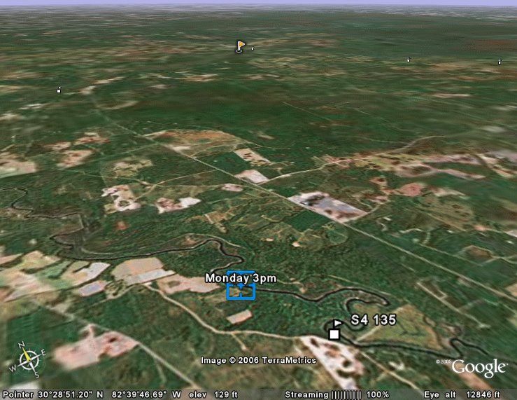 At right is a view of her location at 3:10 PM (blue square) looking back towards Fargo (flag).
SB said they were all feeling the effects of the portage effort, "we're all in a funk today... feeling lazy". They started at 7am today because it was so cold in the early pre-sunrise hours that their fingers don't work at all. It has been near freezing overnight for the past four days. The predicted low for tonight is better at 42 degrees F.
SB said the Suwannee River so far is prettier than the St Marys River and worth a return trip in the future. Here is a collection of photos available at the Suwannee River State Park's website: www.floridastateparks.org/suwanneeriver/Photos-Park.cfm
 At right is the location at 3:10 PM, 32 miles downriver from Fargo. Her location at 9:20 PM, 45 miles downriver from Fargo would be located 13 miles SW of the orange pushpin.
The image at the following web site gives a great overview of the Suwannee River system. SandyBottom was paddling the section just north of and down to Big Shoals today.
http://gulfsci.usgs.gov/suwannee/images/watershed2.gif
No photos yet of SandyBottom at Big Shoals today (it was dark) but there are many images of Big Shoals to be found on the web. Here are two beautiful photographs by John Moran, Florida Nature Photographer. Please visit his web site....
http://www.johnmoranphoto.com/water_005.html
His collected work on display at this website is well worth while as you might begin to see from these two fabulous examples [(c) John Moran] which focus on Big Shoals:


No comments:
Post a Comment