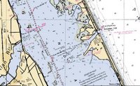
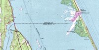
There are intercoastal waterways, rivers, the Gulf coast and the Atlantic ocean, and various inlets that I need to become familiar with. All this including marking out the checkpoint and stage locations. I'll need to research tides and currents, and try to find potential campsites.

This Ultimate Challenge, will require many more charts and hours and hours of planning and routing. I spoke to Maptech about charts ( I think theirs are the greatest waterproof paper charts), and they offered me a new product, their Chart Navigator Pro GPS software, to use for my route planning.
I've just started working with it, WOW AM I IMPRESSED. The package contains 13 ChartPack DVDs that cover the entire United States coastline with detailed raster charts, vector charts, Contour 3D charts, Navigation Photos, Topographic Maps, integrated Gazetteer and more. It’s all the software and charts I need in 1 box!
Lots to learn (so many great features), and very easy to use. I am really enjoying the simplicity of quickly switching back and forth from a NOAA raster chart of a specific area, to a satellite photo of that area, to the topo map of the area. Waypoint and route setting are easy and quick to set, and change as needed. The software also has tide and current information that is extremely helpful in my planning.


As I prepare, I will post updates on my progress, features of the software that are most helpful, and decisions I'm making regards routing. I am also hoping to develop a new page on my website that will cover planning and preparation for the Challenge. This will include my work on navigation plans as well as topics on equipment lists, boat packing, camping plans, etc....
So much to do, so little time left.


