Day17 is Monday, March 20. At the end of Day16, SandyBottom had completed about half of the 210 miles between CP5 and CP6. From Daytana, she aimed toward St. Augustine and paddled from 5 AM to midnight (19 hours). She covered 54 miles and reached a campsite in the harbor area.
A set of photos and videos collected since March 1 are available for viewing at this website...
http://www.watertribe.com/ChallengeViewer/default.aspx
(Some people with dial-up connections to the internet have reported having trouble fewing these; they might try using some other higher-speed connection; for example, at a public library.)
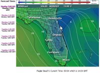
The winds are forecast to be from the favorable direction (south or southeast), but so far today the wind speed has been low in SandyBottom's location. "Not a flag is moving." The following chart from www.intellicast.com shows the situation at 7:00 AM (today, Monday March 20).
Blue indicates no wind. Green and warmer colors indicate increasing wind speeds.


1 comment:
Go Dawn!!
Katja (from Spinning)
Post a Comment